Cruising

Transatlantic: Day 2

The blue ocean lays out before us as a magical wonderland of flatness. We can not see land, but we do see the turquoise clouds over the shallow waters of the Abacos islands in the Bahamas. There are still a few ships on the horzion, but none are close to us.

Our glorious push from the Gulf Stream is given up as we slowly drift our way towards the 1020 line. Winds are light and seas are flat, but we have hopes of wind once we make it to the 1020 line.

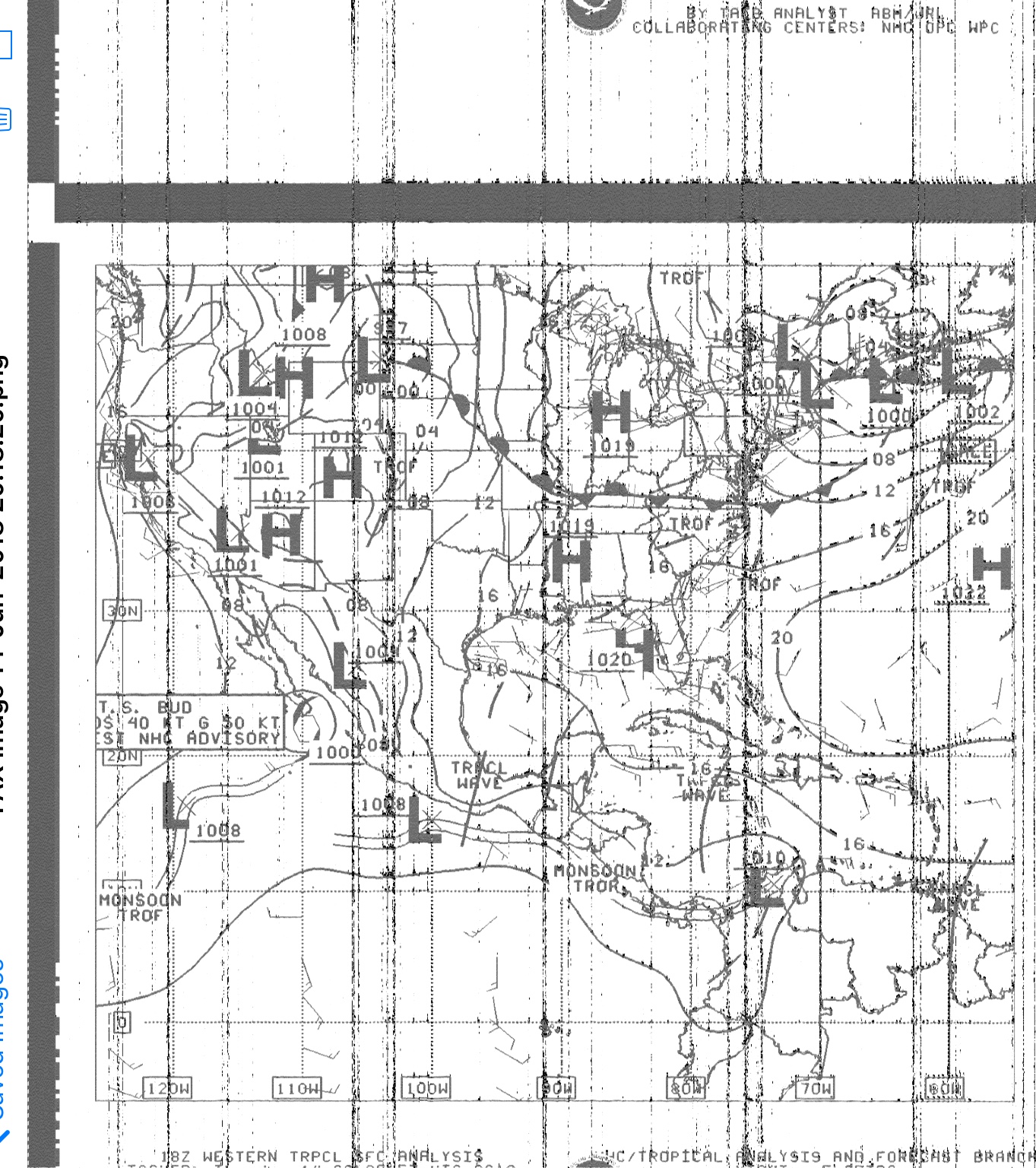
Why don’t we turn north? Let’s look at the weather fax!

FullSizeRender.jpg

Oh yeah, sometimes the weather fax looks like crap! I couldn’t get it to tune in until the region of our location was already over with, so I got a very ugly chart of the weather around us, but not where I am at the moment. What does show is the westward border of the 1020 line.

It was at the longitude of Haiti when we left, but now it has pulled back and is almost at the longitude of Puerto Rico!

Why not just give up on chasing down this mythical holy grail line on a atmospheric pressure chart and just ride the current north? Well, if you look up north, you will see “GALE” written up there. It turns out there were these massive gales that were stationary up there and really messed up the Annapolis/Bermuda race that year. One of my friends was on a boat in the race and the captain actually abandoned the race and returned to the Chesapeake Bay after having so much break on the boat! Needless to say, we wanted a nice “smooth sail” to the Azores, and heading into a gale was not in our cards.

Instead, we continued to drift along slowly.

FullSizeRender.jpg
FullSizeRender.jpg

The pressure chart was pretty worthless for weather planning, so I also collected the wind/wave charts as well, hoping to piece together a cohesive story for what the weather was doing around us.

It appears that the winds north of us seem to be rather squirrely, blowing in all different directions and different strengths. The wave height is pretty uniform as well, so we decided to keep creeping east towards the 1020 line, even though it was now hundreds of miles further away.

Transatlantic: Day 1 Weather Report

You might be wondering: What determines when is a good time to leave?

The obvious answer might seem something like: “If it’s not storming” or “If the winds are good”, but these are all too general and don’t really tell you anything of use for planning a long voyage!

The truth is, you want wind in order to sail, and with wind comes waves. So a glassy calm day might look like a peach to leave on, but you won’t get anywhere! At the same time, wind strength is worthless if you don’t take into account the wind direction as well! Wind on the nose might be a great reason to wait it out a bit longer in the harbor while comfortably anchored and reading a book. Strong winds from your stern will give you a great push and a wonderful (and spirited) sail towards your destination.

Now, how can you tell when the weather is going to be good for a long voyage? You can’t! Forecasts are so horrible that more than 48 hours out, forecasts are a total guess! You need to have your boat provisioned and ready so that when the weather looks like ti will be good, you can leave in a days notice.

So, what are you actually looking for to tell you “This is a good time to leave” or “This is a bad time to leave”. The answer is very simple. On a weather chart, you will see a pressure line called the 1020 line. This line shows you the border of this air pressure and it is a great time to leave (as long as the wind is going in the right direction). The wind on this line will always flow clockwise along this line, as it makes a circle over the Earth. This line is usually going to have steady winds of around 20 knots (but not always as we have found out!). When this line is coming over you, you can slip out of your mooring and make your way out to sea!

With this wind, you will have the ability to make your way far from land, so that if you encounter a storm, you have plenty of sea way to avoid running aground.

FullSizeRender.jpg

As you can see on the chart above, the 1020 line is denoted by a number “20” and it is pretty much over Haiti. We are currently on the west coast of Florida, so there is an entire country (the Bahamas) between us and the “good wind” of the 1020 line. We should have waited for it to move closer to us, but instead we left in the very calm weather and slowly sailed towards it.

The normal route is to leave Florida and hop into the Gulf Stream. This giant conveyor belt carries you along at speeds of 1-5 knots in the direction you want to go! This means that even if the winds are light, you get a push from the current and make great miles towards the Azores.

Instead, we left, crossed the Gulf Stream, said goodbye to it’s help, and made our way towards the 1020 line.

Transatlantic: Day 1

The day was June 14, 2018. We were not ready, and we were never going to be ready, but today was the day that we left on our voyage. Knowing then what we know now, we would not have left on this date. If fact, we would have waited about a full week more before setting off on the voyage.

Why did we leave at the wrong time? Improper management of crew. We had a crew member that was not a good fit for us, and we were trying to make it work out.

Huge tip: If you have crew, it should work before you leave port. If you are struggling to make it work in port, problems are only going to escalate out at sea!

Our crew member was a firm believer in following a schedule and would become angry and belligerent if a schedule was ever broken. Easy fix: Don’t have a schedule! Haha, if only it were that easy of a fix. He would take it upon himself to make a schedule and then force everyone to hold to that imaginary and arbitrary schedule that he came up with.

Why did we bend over backwards for him if he wasn’t a good fit? Everyone told us we needed to have crew for such a journey (but we had never asked anyone who had made the voyage if they needed crew) so we felt obligated to keep him along. We were worried that he would leave us and we would then be in a scramble to find crew for the crossing in a really small window of time. We then made the horrible mistake of thinking we were better off appeasing his uncalled for schedules instead of telling him where he could find a crew position where he calls the shots!

Maddie and I discussed in private our options:

Option 1: Tell him where he can put his opinions and schedules, but risk having him walk away from the boat and leaving us without the perceived need of a crew member.

Option 2: Shove off and float around while we wait for better weather and then start making our way to the Azores! He can’t abandon ship if there is no land in sight!

IMG-3316.jpg
FullSizeRender.jpg

We chose Option 2, but this was a huge mistake! We should have chosen Option 1 and had a great time crossing when the weather was right. Learn from our mistake: You don’t need crew, and you should wait for the right weather!

We left West Palm Springs on June 14th with the outgoing tide. We slowly made our way from land, and we were all watching the lights slowly fade away on the horizon. We were now sailing, and the voyage has begun!

We made pretty good time, leaving in the afternoon and making our way from land through the night.

In the series of blog posts to follow, the maps will have highlighted the distance covered in a 24 hour period from Midnight to Midnight. In our log book, we kept track of the miles covered in a day from Noon to Noon, because I was measuring these distances with a sextant by taking a noon sight.

Pig Beach, Bahamas

IMG_3222.JPG

This beach is photogenic, and it seems that everyone who visits it hypes up how great it is.

IMG_3221.JPG

Think about it, you are at a beach and there are pigs swimming! How cool is that? Where did they come from? How did they get here? Why are there pigs on this beach?

At first, we were sucked into the hype and thought it was so amazing. After a few minutes, the magic passed and we realized what was really going on.

Drunk tourists were picking up the squealing piglets and then dropping them, because they are drunk and a squirming piglet is hard to keep a hold of. Everyone is wasted at all hours and the beach is littered with pig turds.

The original pigs lived deep in the island, surviving by foraging and drinking the fresh water found deep inland at a natural freshwater lake. No one is sure how those pigs got there, but they were discovered and soon it became a tourist attraction.

We feel that seeing those pigs would have been awesome! These pigs, not so much.

The current swimming pigs come from Nassau and are brought to the island by a local company that feeds and waters the pigs. The pigs regularly die from ingesting sand, and are promptly replaced, because there is a huge industry revolving around the pigs at this beach.

IMG_3223.JPG

The pigs now exist solely to bring tourists to this part of the Exumas. While at Staniel Cay (the closest island with an airport) we overheard the local tour guys with the boats. They charge $400 per person to take you over to see the pigs. $400! I saw one savvy tourist negotiate the price all the way down to $150 per person. This seems really ridiculous since the pig beach is about 1 nautical mile away from where the tour boats are located.

I’m not saying that Pig Beach was a waste of an area to go, in fact, this anchorage and location was my favorite spot in all of the Bahamas, but we only went to the beach twice. Once when we first got there because of all the hype, though the magic quickly faded; and a second time a few days later to see if we would like it more when the beach was less crowded. Sadly, the pigs are exhausted and do not want to deal with people. Most of them run away from non-locals, and one of them will bite your butt (literally, her name is Karma and she will bite you in the butt).

A few hundred meters north of Pig Beach is Cruisers Beach, and we loved watching the sunsets from here. A little bit south of Pig Beach is the Thunderball Grotto, a cave that is filled with more colorful fish than it has water! Right behind the grotto is some amazing coral reefs to explore as well.

The main reason why I enjoyed this anchorage so much is the proximity to a grocery store. It seemed that most of the Bahamas was either “city with no scenery” or “scenery with no civilization”. Nassau in New Providence is the prime example of this. While the beaches are public, the house by the beach is owned by someone so wealthy that they pay a police officer to patrol the beach and not let cruisers land there (yes, a public police officer being paid by a private citizen to keep people off of a public beach; doesn’t sound too legal to me). The Berry Islands were the opposite, they were beautiful but completely deserted. You had to stock up before you went there because there was no store to pop into and pick up some more pasta sauce.

FullSizeRender.jpg

Staniel Cay hosts two, rather small but still existent, grocery stores. If you needed more food, you could dinghy over to it and walk a short distance to the store where you could buy fresh fruit and vegetables (which will rot quickly so only buy what you are going to eat in a few days).

FullSizeRender.jpg

So the anchorage by Big Majors (the island with Pig Beach) has beautiful snorkeling, grocery store access, awesome sharks you can swim with at the marina on Staniel Cay, and a great beach to relax on (not the one with the pigs).

IMG_2892.JPG

Balancing Life and Cruising

When you are at work, you dream of casting off the lines and sailing out into the sunset. There are no more rules, no more worries, and best of all, no more stress!

The reality is a bit different from the dream. You still have local and international rules to follow, and the customs agents can be very strict if they feel you are not taking them seriously enough.

No more worries, well, you have forces of nature and gear failure to worry about now. Instead of boss breathing down your neck, you have a squall! The big advantage is clear skies really do lift your spirits because it means the weather has cleared up and your worries have vanished as fast as the clouds did!

No more stress, also not entirely true. Instead of arbitrary work deadlines imposed on you, you now have to contend with weather windows.

The truth is, there is always something going on around you that needs your attention, and there is no further vacation to take once you live in a permanent vacation. This is where state of mind becomes very important.

You have transcended from your old job into a world that you used to imagine. This is the dream life you were waiting for and you can’t really escape in a daydream to anywhere else because your old day dreams have become your reality.

When something is bad, you need to fix it because you need to get back to the happy state. The more you have the more projects you will have to keep them all operating. For this reason, you need to set aside some “ideal time” where you get to live the life you imagined. You need to make time to sit on a beach and drink a fruity cocktail or a beer.

Work will always be there to do, but life is short and there is a reason you left the rat race. So, when you are given the choice to buy a fancy gizmo “that will make your life easier” think about it this way: Would you rather be fixing that piece of equipment or would you rather be sitting on a beach under a palm tree watching the sunset over your boat in the anchorage?