Navigating

Weather Routing Software

You head out to sea because you want to sail to somewhere far away, but which way should you go?

Wind direction can have a drastic effect on your ability to cover ground under your keel. If you are running, it will be slower than a broad reach, and still slower than a beam reach, but certainly faster than if you are beating. What does this all mean?

It doesn’t matter because there is a computer program that will interpret all the weather data and spit out a simple command: “GO THAT WAY”. You no longer need to know what you are doing or why you are doing it because a computer will tell you everything you don’t understand.

IMG_2630.PNG

The program takes the forecast information and breaks it down into 4 scenarios depending on the models. There is the US and the European model, as well as the Predict Wind version of each. The colorful program even shows you where you will be at each time interval and which direction to go next!

IMG_2626.PNG

Look at the little boats scoot across the hypothetical screen, aren’t they cute?

IMG_2659.PNG

Looks like the GREEN boat is in the lead, woohoo!

IMG_2629.PNG

Come Friday, the yellow boat seems to be the slowest of the pack!

IMG_2636.PNG

RED and GREEN seem to be neck and neck!

IMG_2623.PNG

RED has taken the lead!

IMG_4281.PNG

Here is another lovely example of a program playing the role of Captain while you are merely a deckhand to the computer overlord. Hurricane Chris is looming to the NW of the boat and the computer is suggesting that the GREEN boat should head up into the hurricane and sail on its navigable semicircle.
Why? Because the hurricane is predicted to move straight and this would give you favorable winds to sail quickly.

What if the hurricane turns Easterly? Now what?

Weather routing software is nice to confirm what you have already decided is prudent and best. It can be used to run out theories in your head, but it should not by any means be the Captain of the ship. The software runs under the premise that the forecast is correct and as we all know, the forecast is never correct. This means that the suggested route is not going to be as expected!

If you still feel the need to have a program tell you where to go, don’t go to sea yet. Take some classes on weather and weather routing, read some books, and learn the material yourself. First, so that you can judge if the electronic information is prudent, and second, so that you can still navigate the weather should your electronic leader die at sea.

Transatlantic: United States to The Azores

When we left Baltimore in the Summer of 2017, we thought we would be in the Azores by Chrismas 2017. Well, we made it, but with a lot more time and distance in getting there!

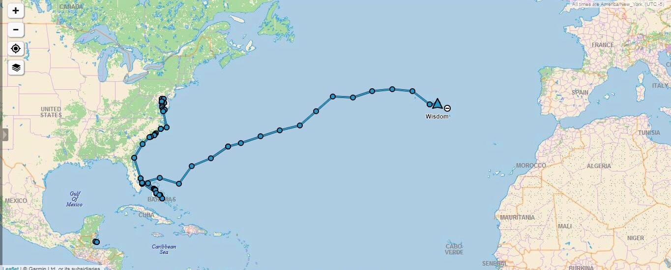
We honestly were not ready yet to cross an ocean when we first set sail. Looking at this map, you can see that when we decided to head to the Bahamas to ride out the winter and made our way south, we clung to the coastline!

We were planning to cross an ocean and at many points felt like we were far from land, but the truth is, we were smack up against the coast the whole time.

IMG-3372.jpg

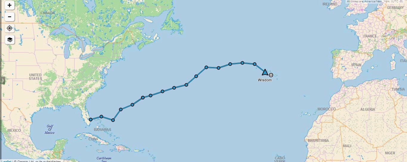
By the time we made it to the Bahamas, we had gotten the experience we needed to feel confident and comfortable with heading out to sea to actually cross an ocean. No longer did we watch shore disappear behind our stern, no longer did we worry about getting far from land.

IMG-3376.jpg

When we left Florida for the Azores, we were ready. Nothing had physically changed with us, but a mental transformation had taken place. We still had the same gear and the same thought processes about when to use certain sails, but our attitude about everything had changed drastically. Now, we were heading out to sea and the thought of land sickened us. We wanted to head straight away from land out into the blue horizon where we would point directly towards our next destination.

IMG-3374.jpg

The trip began at the wrong time, for the wrong reason, and in the wrong direction.

We left Florida when the weather was not right to cross the ocean because the summer weather patterns that grant you safe passage had not occurred yet. We should have waited another two weeks for the weather to be correct.

We left to appease our angry crew member because we were worried that he would abandon us and we thought that we really needed a crew member to cross an ocean, so we left port to appease him and shanghai him (there are no airports out in the middle of the ocean) so he couldn’t abandon us.

To try and make our way from land, but avoid the nasty storms up north, we traveled way to far east. This placed us into the doldrums with no Gulf Stream to help carry us through the windless region.

IMG-3371.jpg

We learned some very valuable lessons on this passage.

First: Don’t have crew.
Second: If you have crew, you don’t have to please them, they have to please you.
Third: You call the shots, not the other way around.

We stopped in Bermuda to drop off our angry crew member because we realized that we didn’t need crew (or his giant ego and bad attitude) to make the crossing.

This passage was insanely slow and was full of mistakes that we learned from and would not repeat!

IMG-3375.jpg

Maddie and I waited in Bermuda, in St. George’s Harbor, for the winds to be perfect for us to leave. While we waited, we had a grand time exploring Bermuda and getting to know the locals. Once the winds were correct, we left and had a wonderful and fast passage to the Azores.

IMG-3377.jpg

We stopped listening to the weather forecasts on the way to Bermuda because they were always wrong. We instead looked at the clouds to read what is really going on up in the sky. Using this method, we were able to sail on the rhumb line straight to the Azores, until we got caught in a high pressure system for a few days and were totally becalmed.

Being becalmed for a few days was the worst weather we had. While crossing, we had gales to the North, Hurricane Chris to the West, and trade winds all around us, but by looking at the sky, we were able to keep ourselves safe from powerful winds and simply relax in light winds.

The crossing was very surreal, we saw things that could never be imagined, like one night where photosensitive bio-luminescent creatures illuminated the ocean with as many lights as the stars above in the sky. On another occasion when the ocean calmed down completely, the entire surface was covered in a snow of micro plastics.

Now that we have made our first ocean crossing, we feel very confident that we can do it over and over again as we voyage the world and visit ports all around the Atlantic Ocean.

Transatlantic: Day 26 [Day 47]

Yesterday, we saw land for the first time in 25 days. Then we kept on sailing and never stopped. Our destination lays a few hundred miles further east.

IMG-3370.jpg

As you can see, we chose to enter the south side of the island because the winds looked like they might start coming form the South. Yes, having a lee shore is not fun, but at the same time, fighting a wind shadow and then trying to short tack in a narrow straight is not fun either.

IMG_2597.PNG

Over night, we had our best and fastest run ever! We averaged 6 knots and were doing over 8 knots for most of the night. This is wonderful because we were expecting to fly our light air sails that we had made for the Azores High. Instead, we were flying our regular sails with a reef in them. We were a bit overpowered and normally would have reefed down, but we needed to make all the miles we could while we had the wind. The next day was supposed to be very light winds and we wanted to make it to port before it got dark so we wouldn’t have to wait another night hove to outside of the harbor while we wait for dawn.

FullSizeRender.jpg

In the morning, we saw a sleeping sperm whale at the surface. The whale looked like a large flat log, only apparent when it exhales and creates a giant cloud of mist.

FullSizeRender.jpg

The distinct blow from a whale is easy to spot out on the distance which gave away their position in the times of whaling. Sperm whales were hunted with efficient strategies and hand launched harpoons from tiny boats all around these islands for hundreds of years.

FullSizeRender.jpg

As we rounded the SW point of Faial, a pod of dolphins came out to greet us. This was a very magical moment and as tired as I was, I could not help myself but stare at them as they swarmed around our sailboat.

FullSizeRender.jpg

It almost felt surreal. The first island we passed, Corvo, has no civilization on the northern shore, so to us it just looked like an island with fields partitioned with hydrangeas. Faial on the other hand is a settled island with many cities that were established hundreds of years ago. Seeing the very European architecture from the water felt like being transported back to another time.

FullSizeRender.jpg

The highest point in Portugal, Pico, is visible just to the left of the leech of our jib. That massive volcano reaches up from the bottom of the ocean, some 4000 feet beneath the surface and then stretches up several thousand feet into the air. If you took away the water, Pico would be an epic mountain!

FullSizeRender.jpg

The sounthern shore of Faial is so quaint looking. There are fields and buildings, all with a similar architecture; terracotta roofs with white walls, all set on the hillside.

FullSizeRender.jpg

As we neared the harbor, we were presented with a massive volcanic creation that helps shield the harbor from the ocean waves.

FullSizeRender.jpg

After being isolated from civilization for so long, this is now what we get to gaze upon. This quaint little town. We never got this kind of a welcome in the United States. When you enter a harbor, the waters edge is lined with factories, or ugly boxy buildings. There is no style, no form, and certainly no aesthetic value put into the shorelines of the American ports. The towns do not display their beauty towards the water. American towns are pretty (some of them) once you are walking around them, but from the water, they look boring and plain.

This town showcases the style of buildings you can expect to find in the inter-lands of the island. More importantly, this town was designed to be approached from the sea and therefore the buildings are set to face the arriving boats. You can tell that the goal here was to make the town pleasant to greet arriving ships and their passengers.

FullSizeRender.jpg

After almost a year at anchor, mooring, or sea, we are now tied up to a cement quay. We have traveled a long ways and we feel like we have accomplished a great feat, but every other boat in this harbor has also crossed an ocean to get here! This is a port filled with true bluewater cruisers.

Transatlantic: Day 25 [Day 46]

Aug 1st, 2018. We have now entered the Azores, and with great speed too! Our average speed for this 24 hour run was a whopping 5.5 knots.

IMG-3369.jpg

At dawn the horizon was still empty, but I knew land would be visible soon. We decided to sail close to Corvo because we wanted to see some land before we made our way into the archipelago.

FullSizeRender.jpg

While the horizon might look like more water, there is a give-away written in the clouds! All clouds move, but clouds over an island will tend to be stationary.

While staring ahead, I noticed that the clouds just above and to the left of the gate never seemed to move. All the clouds were moving from right to left over the horizon, but those clouds were stationary. LAND!

FullSizeRender.jpg

We kept sailing in that direction and soon I could see the faint outline of the cliff sides of Corvo rising up out of the water!

FullSizeRender.jpg

A while later, we were several miles closer to the island and the outline of the landmass seems more pronounced on the horizon.

FullSizeRender.jpg

The original plan was to sail between Corvo and Flores as we entered the Azores, but I was worried about wind shifts from the cape effect as we passed through the narrow straight between the two islands. I was also concerned with the current that might exist in there as the tidal waters moved from East to West. According to the tide tables, it was supposed to be high tide, so we might be approaching the pass at peak ebb tide and be pushed back unnecessarily!

Instead of risking it, we simply put Corvo on our starboard bow and continued to make our way towards it.

FullSizeRender.jpg
FullSizeRender.jpg

We passed the island on the North side and stayed close enough to appreciate the beautiful sight of land but far enough to keep safe from the dangerous shores that we saw before us.

FullSizeRender.jpg

Passing the island on the North side while sailing on starboard tack means that we were not going to have a lee shore, but we would have to negotiate with the islands wind shadow. The wind shadow of an island can extend for miles, as it is roughly 8 times the length of the objects height. On a massively tall island like this, the wind shadow could easily extend for miles out to sea. Thankfully, the island is small so the wind shadow would be short lived as we drift across the waters while being pushed by the current.

FullSizeRender.jpg

As we neared, we were graced by the presence of something we hadn’t seen in a while: birds.

FullSizeRender.jpg

This guy looks like a brown albatross from a distance, though I am not a bird watcher by any measure. It was merely massive, huge, glided around without flapping its wings, and had a beak that resembles that of an albatross. Most importantly, this bird has land behind him!

IMG_4168.PNG

We have now entered the Azores and were close to our next port.

IMG_2594.PNG

We passed rather close to Corvo and once clear of the wind shadow, made our way towards Faial. Horta is located on the SE side of the island, but the winds were acting kind of fluky, so I decided it would be best to head straight there in as short a distance as possible. If we could get close to the island, we could then day sail our way into port without any major distances to cover. If we hedge our bets on what the winds will do, we might find ourselves far off with the wrong winds and no motoring ability to correct the mistake.

FullSizeRender.jpg

Seeing land after 25 days is magical. The horizon used to always be empty, and all of a sudden, there it is, the missing vision we have been searching for!

Transatlantic: Day 24 [Day 45]

The day has arrived, the day when we turn towards the Azores!

You might be wondering how we decided when to turn? Was it because Predict Wind said we should turn? Was it because someone told us to? Or was it because the clouds said it was time?

Well, a little of some and a lot of the others.

IMG-3367.jpg

Our Australian friends and our friend in the States both were away from their computers today, so we didn’t hear from anyone until late that night when they both told us that we should turn South towards Faial. At that point we had already turned!

What made me make the decision to turn? The clouds and the compass.

The weather was changing overhead and the high pressure was being pushed further to our stern, meaning that we would be able to turn without getting caught in the windless region of the high pressure system that was off our starboard side.

The compass was really the important one in this decision (as it should be). I knew the course we would be holding to get to Horta on Faial, and I decided that it would be best to sail a bit further East before turning so that we would be on a broad reach instead of a beam reach. Why? If I’m wrong about the winds on a broad reach, they will either be a run or a beam reach. If I’m wrong about the winds on a beam reach, they will either be a broad reach (which is fine) or a close reach (I hate beating)! I don’t want to run that risk!

So I simply sailed until the bearing to Horta was going to be a course on the compass that would have us on a broad reach with the low pressure that was coming in!

The other giant sign in the sky was the clouds literally turned at that point and basically lined a path that pointed straight towards Faial, the way they were blowing, it looked like a good track to be on and follow the weather system into the island chain!

IMG_4167.PNG

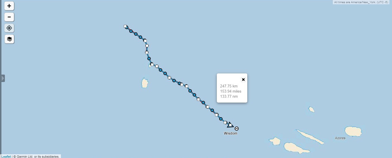
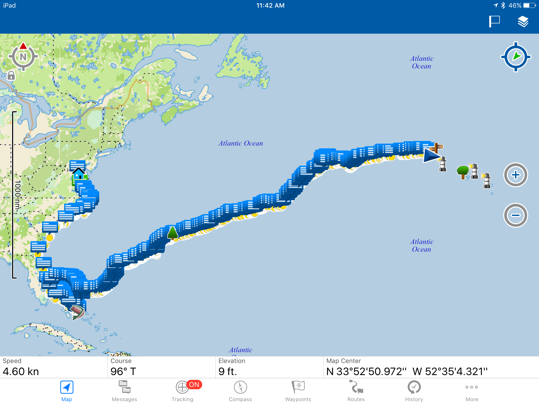
You can see here, we made it to around the area of our little sign post out in the ocean (on this digital map) and began turning towards the Azores! My, how far we have come!

FullSizeRender.jpg

The other good part about staying with the winds is it helps keep us charged up! Our batteries got a little low during that period of no wind that we had. We really like having fresh food on the boat, and to do that, we need to power the biggest most power hungry monster in our yacht: the fridge. This monster chugs the amps and just gives you the cold shoulder! Our house bank got a little low so we were supplying power to the fridge from the motor bank. That drained the motor bank down quite a bit though!

All this fast sailing we are having is great because our electric motor works as a hydrogenerator when sailing fast and that produces the power needed to charge the batteries back up!

Here, the display is saying that we are generating 6 amps at 48 volts. When you step that down to 12 volts (to power lights and the fridge) those 6 amps become 24 amps! That is some serious power it can generate and that is crucial because we will need power when we enter the marina and need to dock.

IMG_2637.PNG

Looking ahead at the information from Predict Wind, you can see that they are calling for the winds to be pretty good for the next few days, and then get kind of light. I don’t really care much for these kinds of charts because it all seems like guesses to me. I like when they are all agreeing, like they do for the first few days (because they are all working with good data) but then the radical spread occurs where one is calling for winds of 4 knots and another is calling for winds of 15 knots! All this tells me is that further out, no one knows and I should just ignore the computer programs and look to the sky to read the clouds.

Clouds tell you the weather you are having and going to have because they are generated by the very weather you are seeing and experiencing. I would much rather look to the sky for my weather than to look at a computer screen generated by a program written by someone who is guessing based on incomplete data.