Forecast

Forecasts

We all know the joke, how can the meteorologist be wrong so often and still keep their job?! They say it will rain and it's sunny, they say it will be sunny and it pours! Out on the ocean, it's no different.

We have friends on shore giving us weather information for our area as well as downloading Weather Fax broadcasts. The information was a total shot in the dark.

The wind speeds were always off, air pressures were usually close but still off, but the wind direction was pretty spot on.

My favorite was when we were stuck in the doldrums and our friends on shore asked why we weren't moving. "The weather app says you should have 15 knots of wind" yet we were becalmed for a week!

After a while, I stopped downloading the weather faxes too. It seemed that I could get a more accurate weather forecast by asking a passing seagull.

When we left Bermuda for the Azores, I didn't even bother to check weather forecasts. I checked to make sure no hurricanes were coming and then went to sea. Our friends kept telling us to head north of the rhumb line to avoid a massive high pressure system that would have no wind, yet day after day, the clouds said we would have wind and wind we would have. Winds varied between 20 and 30 knots for the entire week, while the forecast said we would have winds of under 10 knots where we were.

A week into our voyage, we did turn north because the clouds of a high pressure system appeared in the far off distance. I did not fear losing wind because I keep us surrounded by clouds that have wind. Storms, squalls, and good winds can all be seen by looking at the sky and reading the clouds.

This is how you get your forecast for what is happening now where you are. If you know how to read the clouds, you can even get hints about what's coming tomorrow and the next day! No data or internet connection required, just a barometer and a weather eye to keep you in good winds as you cross the ocean.

Reading Isobars

Isobars are the little lines on weather charts that tell you what the barometric pressure is across the landscape. Isobars are the demarcation line where the pressure will be the same along its entire length. 

Wind travels along the length of the isobar, and the closer the isobars are, the stronger the wind will be. Wind travels counter clockwise around low pressure systems and clockwise around high pressure systems. This means that the wind wil travel to the left or to the right along the length of your isobar depending on the location of the high or low pressure systems around it. 

While wind speed is estimated based on the proximity of one isobar to another, there are subtle variations based on line curvature. We have all had those days when they forecasted wind but it was dead calm, or they forecasted light winds and you needed to reef all the way down! What happened?! 

The answer is simple, the isobar curved in your area and altered the wind speeds. If an isobar curves inward, creating a point that the wind will whip around, the winds will be faster. If the isobar curves outward, creating a divot in itself, the winds will calm down as the transit this area and give you much calmer winds than expected. 

IMG_2126.PNG

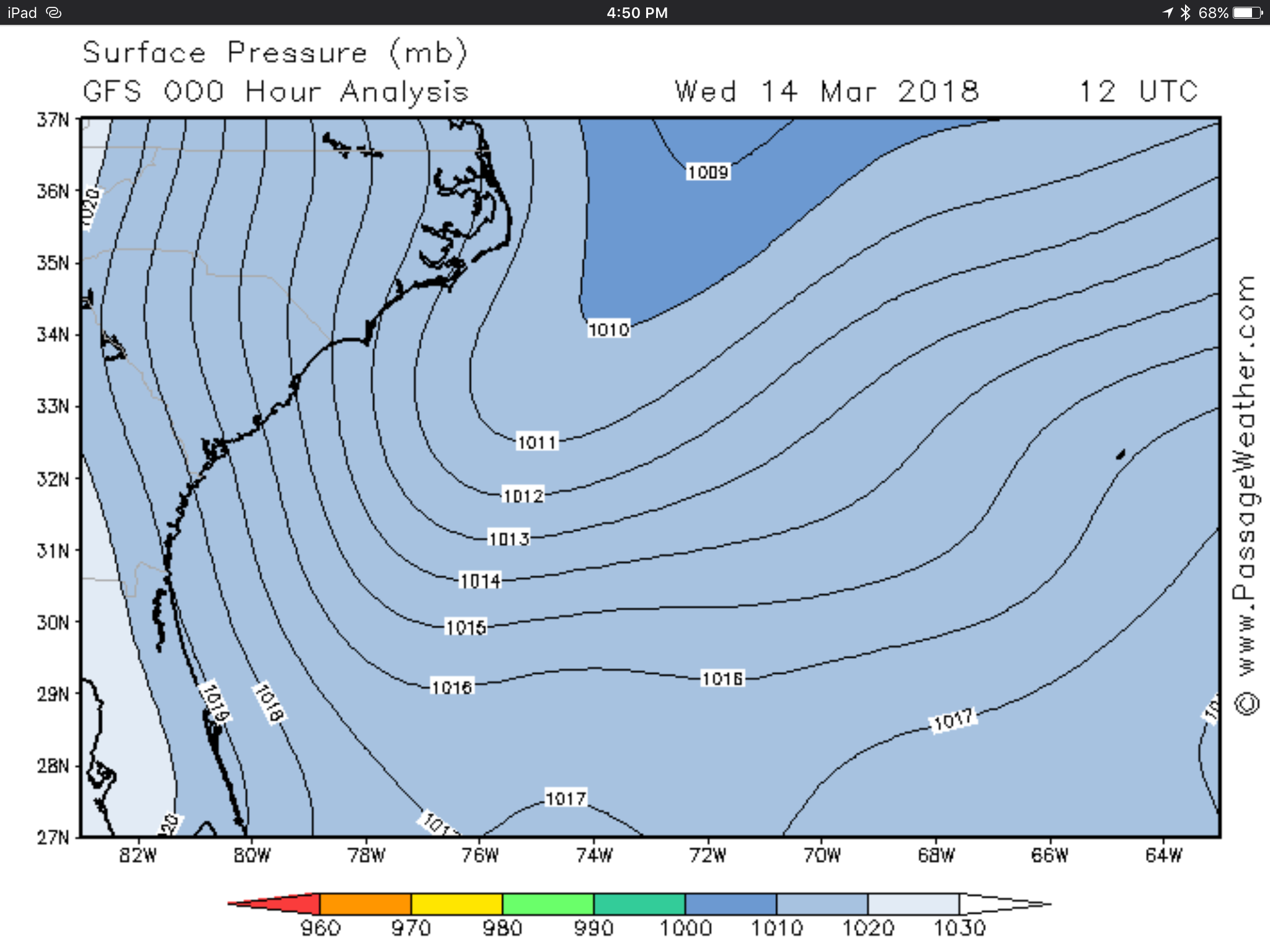
These isobars are extremely spaced out. There is considerable distance between each millibar of air pressure. This would tell you that the winds will be light in the entire area. Since the top of the screen has a low pressure center, you know that the winds will be moving counter clockwise or from left to right on this map. On the bottom left, you can see a high pressure area, so its winds will move clockwise or from left to right on this map. 

Now, the 1010 line makes a pronounced point, so the winds in this area can be expected to be rather higher than the surrounding areas. The 1017 line at the very bottom near 75W makes an outward turn, so the winds here can be expected to be even slower than the surrounding areas. 

IMG_2127.PNG

Looking at the windbarb map, we can see that the winds near the point of the 1010 line are stronger, and the winds just above 75W are rather slow. 

IMG_2123.PNG

Looking at a global map of the Atlantic Ocean, you can see a high pressure system in the middle of the ocean and two low pressure systems at the top corners. 

The high pressure system in the middle is called the Azores High, and is a famous pressure system that remains constant through most of the year. This will generate a clockwise rotation of wind around it. 

Each low pressure system in the top corners will generate a counter clockwise rotation of wind. 

The intensity of the wind will be caused by a few factors. First the high pressure area has widely spaced isobars, so the winds here will be light. The low pressure areas have very close isobars and a very drastic change in pressure from outside to inside. This will generate a very powerful wind as you approach these areas. 

The second thing affecting the wind speeds will be the curvature of the isobars. The high has relatively long and straight isobars, so the winds will be rather consistent. The low pressure systems have very tight curves, especially towards the centers. This will amplify the speed of the wind and create an insane storm! 

IMG_2124.PNG

You can see the high pressure area is rather calm while the points and the centers of the low pressure systems are very intense.  

Learning to read the isobars will allow you to better interpret weather data received offshore via weather fax where the image is not always clear and the graphical display leaves much to be desired. 

IMG_2128.PNG

The quality of the image depends on the quality of your signal and receiver. If the unit is not perfectly tuned, the image will be skewed. If you don't like the way your image looks, too bad! The next transmission is in 6 hours for you to try again! 

Learning to read weather maps and isobars will be an invaluable skill when cruising and you are forced to be your own weather forecaster.