Cruising

Transatlantic: Day 7

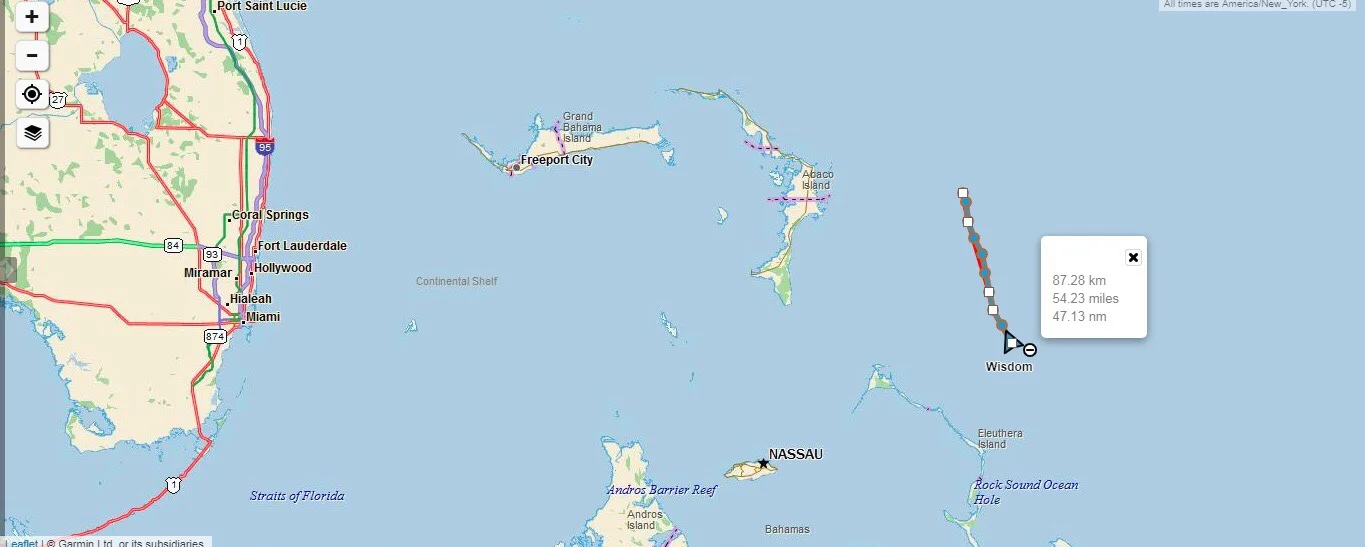
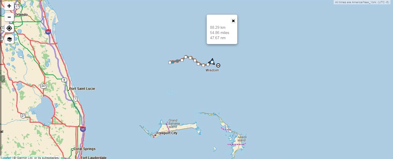
We could not catch a break! The winds that were supposed to occur down south ended up happening up north, back where we were! We quickly turned around and began making our way back to where we were yesterday.

IMG-3323.jpg

What about the winds that we were told would happen? Nope, nothing, nada. We were bobbing around with no wind in sight.

FullSizeRender.jpg
FullSizeRender.jpg
FullSizeRender.jpg
FullSizeRender.jpg

To make that day even better, I couldn’t get a single weather fax to come in! Everything was gray and static!

When we planned our transatlantic voyage, we were planning on covering 100 miles per day since this is average. Being how we are a bit slow, we were expecting to cover 80 miles per day. We are now a week out from shore and still hanging around the Bahamas! That is where people go because they don’t want to sail far away from land go!

How are we supposed to cross an ocean if we can’t even break away from land?

Transatlantic: Day 6

Despair, hopeless, lost? Yes, this is how we felt. We have been sailing for almost a week and we are bobbing around about a hundred miles from the Eluthra Island chain of the Bahamas. We are not moving, we are not sailing, we are just floating around aimlessly!

IMG-3322.jpg

The winds that were supposed to come, didn’t come. We are so far away from the Gulf Stream that it feels like it would take another week just to float our way back to it. When puffs of wind come, we get a little speed, and our angry crew member seems mildly apathetic as our speed could be better if the winds would improve. When the winds die away, he becomes belligerent as the lack of wind must be someones fault. Morale is waning as time slips away.

Maddie and I used to play card games in the cockpit in weather like this. The lack of wind means that our cards won’t blow overboard! Instead, we tiptoe around our crew member, trying to avoid setting him off. This eventually leads to Maddie also becoming frustrated, and that makes me frustrated.

FullSizeRender.jpg
FullSizeRender.jpg

Now we have three frustrated people bobbing around in the ocean with no land in sight. Being close to the Bahamas, we encounter a fair number of fishing vessels that motor past us. The larger ones are courteous and gave us weather reports. The information they had was much more detailed than the ones we received with our weather fax, and it would all promise wind tomorrow.

When we tomorrow become today?

Transatlantic: Day 5

A front is supposed to be rolling in, so we make a straight line shot away from it for two reasons:
1. Bad weather is the opposite of good weather.
2. According to our friends on land that were texting us to the boat via our sat phone, the winds were supposed to be blowing out of the West tomorrow down there at a steady 20 knots!

IMG-3321.jpg

The 1020 line is far away, but if we are supposed to have wind, we will take it!

FullSizeRender.jpg
FullSizeRender.jpg

Looking further out at the weather map of the Eastern Atlantic, it appears that the gales have toned down. At this point there is only one gale hovering west of the Azores.

We head south as we wait for the beautiful winds tomorrow is supposed to bring!

Transatlantic: Day 4

We are still moving slowly. The winds are light, but to the north is supposed to be bad storms, so we begin heading South East towards what should be better wind.

IMG-3320.jpg
FullSizeRender.jpg

The winds are supposed to be blowing us South, so we begin beating South East. The southern component of the route is not ideal, since we are trying to head North East, but at least we are moving East.

FullSizeRender.jpg

Looking further out, the 1020 line seems to be stationary! It is hanging out at the longitude of the BVI! We are a bit concerned because this is mid June, and hurricane season will be starting soon. Heading towards the Virgin Islands right before hurricane season is a risky move, but the winds are being weird and not following the normal routine, so this is what we do as we wait for the weather to improve.

Why are we doing this again? Why didn’t we wait in port for better weather?

We were asking ourselves this same question. Back in the Exumas, when we picked him up, we were waiting for better weather; then the weather started to improve so I gave him a ballpark estimate.

At that time (early June) I told him, that we are still waiting for the Azores High to form and mature. This usually happens in early May, but it hasn’t formed yet, so we are just waiting. Around June 6th, it looked like it would be formed and stable soon, as it had begun its development. I gave him a ball park schedule of: We leave Staniel Cay on June 8th, arrive in Florida on June 10th, and have two days to provision, leaving Florida on June 12th.

Well, we left Staniel Cay on June 8th, but we didn’t arrive in Florida until the afternoon of the 11th. WE WERE BEHIND SCHEDULE!! To appease him, we left on the 14th instead of waiting for the weather to actually be better.

So out here we drift, as we slowly make our way towards an imaginary line in the ocean that should have wind and carry us safely to our destination!

Transatlantic: Day 3

We are not moving! There is no wind, no current, and no progress.

IMG-3319.jpg

When we looked at the weather map, we see gales to the north, and an approaching 1020 line, but we are on the wrong side of the line to get any benefit from it.

Winds rotate clockwise around the center of a high pressure system and counter clockwise around a low pressure system (in the Northern Hemisphere), so the wind of a 1020 rotates clockwise in a direction tangent to the line. If you are on the right side of the circle, the winds will blow you South. If you are on the bottom of the circle, the winds will blow you West. We are pretty much set just under the line, so any contact with this wind will slow us down even further than we already are!

FullSizeRender.jpg

The 1020 line we want is now East of the Lesser Antilles! If we head North, we are going to be tossed around in gales. If we stay where we are, we will not have storm conditions.

FullSizeRender.jpg

Our destination is pretty much in the center of the “H” denoting the center of the high pressure system that forms over the Azores, also known as the Azores High. We want to get there, and usually the route is really simple. Ride the Gulf Stream and the 1020 line around the Atlantic until you are close, then sail on into the Azores island chain.

The issue is there is another high pressure bubble that came off the East Coast of North America and has generated various gales that seem almost stationary at the border of these two giant high pressure systems.

FullSizeRender.jpg

Instead of getting caught up in that whole mess, we continue to drift East. We aren’t moving, but we still have our crew member on board (as agitated as he is with our slow progress through the water) and he can’t leave us!